Canmore, Alberta is one of the best hiking destinations in the Canadian Rockies. With around 70km of trails Canmore has something for everyone. Whether you are a beginner or an experienced hiker, there is plenty to explore in Canmore for everyone. Moreover, it is a quieter alternative in comparison to Banff. This article covers the 12 best Canmore hikes including easy, moderate, and challenging trails.
Let’s check out Canmore hikes and trails…
Bow River Loop
- Difficulty: Easy
- Elevation: N/A
- Distance: 2 km
- Time: 20-50 minutes
- Note: This is a great walk for casual morning and evening walks
Undoubtedly, this is one of the easiest and quick Canmore hikes perfect for all age groups. It is a scenic 2km loop around the Bow river that can be done year round. This entire loop follows a gravel path along the Bow River and two pedestrian bridges. The first bridge is at the end of 8th Avenue and the second bridge is the Engine Bridge. Additionally, there are plenty of park benches along the river’s edge on the trail to take some rest and enjoy the natural views. Moreover, on a sunny summer day you will find a lot of people enjoying a picnic lunch.
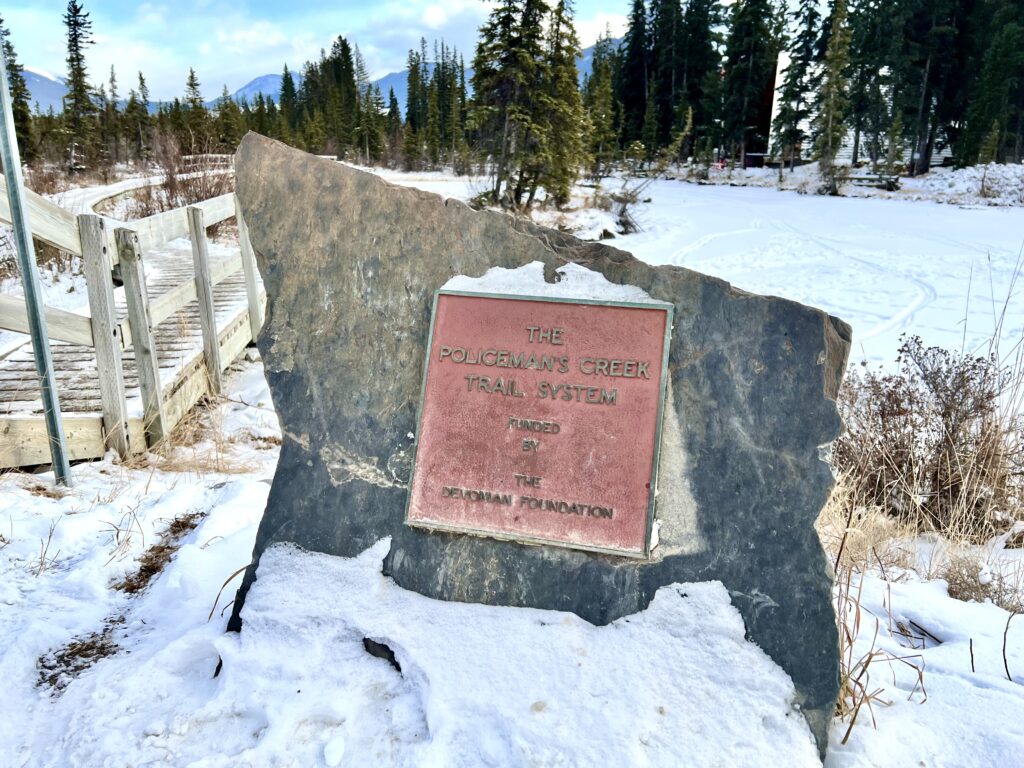
Policeman’s Creek Boardwalk
- Difficulty: Easy
- Elevation: N/A
- Distance: 4 km
- Time: 40 minutes
- Note: A year round trail
Policeman’s Creek is certainly one of the easiest and most accessible walks in Canmore. This flat, scenic trail follows a peaceful creek and features boardwalk sections, bridges, and mountain views. While you can enter the Policeman’s Creek Trail from multiple points, the intersection near the Spring Creek Drive and Main Street is the most popular one. This is at the exact opposite of the Big Head sculpture. You will see ducks swimming on the ponds, birds, and if you’re lucky, you may catch a glimpse of an elk or deer. Additionally, it is open year round and is perfect for families, casual evening walks, and quite popular among photographers.
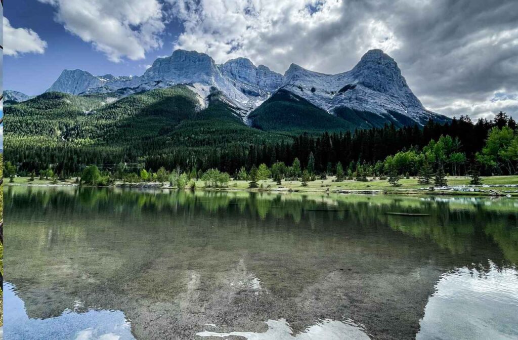
Three Sisters Viewpoint
- Difficulty: Easy
- Elevation Gain: N/A
- Distance: 300 meters
- Time: 20 minutes
- Note: A year around hike
Another easiest hike in the town of Canmore with rewarding views at the end. Although it is impossible to miss the Three Sisters when you visit Canmore. From the parking lot, it is just a five-minute walk to the photo point. It is another popular spot among the photographers. Although there are no markings, park at the town’s off-leash dog park near the helipad on the Bow Valley Trail. You will find a pathway under the train tracks that leads to the photo point in about five minutes.
Ha Ling Peak
- Difficulty: Moderate
- Elevation Gain: 745 meters
- Distance: 7.9 km
- Time: 3-5 hours
- Note: A Conservation Pass is required
Ha Ling Peak is the top choice of locals when it comes to Canmore hikes. The trail underwent a massive facelift in 2019 by Alberta Parks, where proper handrails were installed and steps were constructed to make it more accessible. Although the hike is a tasking one, the views it offers of the Spray Valley and Goat Valley are extremely rewarding. If you can start early, then Ha Ling Peak can stun you with breathtaking sunrise views.
Grotto Canyon
- Difficulty: Easy
- Elevation Gain: 195 meters
- Distance: 4.3 km
- Time: 2-3 hours
- Note: A Conservation Pass is required
Despite posing a steep challenge ahead of hikers, this is one of the top picks of those yearning an adrenaline rush. If you go on this hike then you will pass through steep lanes overlooking a pictographic background consisting of a magnificent waterfall. Easy access throughout the year makes it a hot favourite of both locals and visitors.
The trailhead to Grotto Canyon starts at the Grotto Mountain Day Use Area. Here you will also find a picnic area right next to a beautiful pond with long drop toilets, picnic tables, and trash cans. You just need to follow a well-marked trail starting at the car parking spot for reaching the Grotto Canyon.
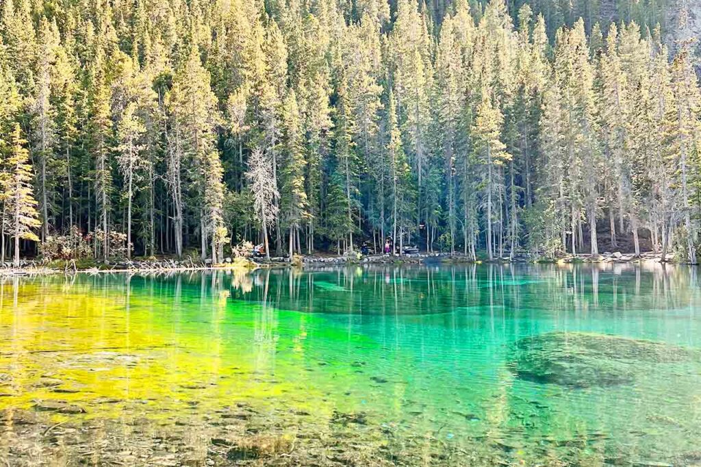
Grassi Lakes
- Difficulty: Easy
- Elevation Gain: 165 meters
- Distance: 3.20 km
- Time: 1 – 2 hrs
- Note: A Conservation Pass is required
Grassi Lakes is a popular trail among first time hikers coming to Canmore, Alberta. It offers breath-taking views of one waterfall and two glimmering lakes in a vibrant shade of turquoise. Close proximity to Canmore town opens up many options ahead of visitors who might head out to the town and explore its eateries.
The Grassi Lakes hike attracts a large number of visitors during weekends given its easy accessibility. Moreover, you will find clear markings all along the 2 km long hike which gains an elevation of 200 meters along the way. The trailhead can be reached by driving 5 kilometers from Downtown or through Roam Transit during summer months.
Canmore Hoodoos (Benchlands Ridge Trail)
- Difficulty: Easy
- Elevation Gain: 195 meters
- Distance: 4.0 km
- Time: 1 – 1.5 hours
- Note: A Conservation Pass is not required
Yes, Canmore has its own hoodoos that you can actually see right from the highway. This 4km trail is suitable for all age groups and excellent for wildlife viewing. This quick and easy hike actually begins from downtown Canmore and also crosses a bridge over the highway. However, there is an easy alternative as well, you can park at either Cougar Creek or the Benchlands Trail Bike Park. Once you park the car you will see the trail and hoodoos. From here you can enjoy the view of the whole town which is awesome. Also, you will find the residents walking and biking here.
Larch Island Interpretive Walking Path
- Difficulty: Easy
- Elevation Gain: N/A
- Distance: 3.5 km
- Time: 40 minutes
- Note: A Conservation Pass is not required for this walk
If you are looking for an easy and relaxed walk, take a wander around Larch Island Interpretive Walking trail. It’s one of the best Canmore walks for people of all abilities. The trail is at the north end of Canmore, on the eastern bank of the Bow River. There is a small wooden bridge along the Bow River Trail close to the end of 16th Street, this is the best starting point. During the fall season, when the larch trees turn gold it is certainly a treat for the eyes. Summer is the best time to admire the wildflowers and birds. Also, keep your eyes peeled for wildlife on this loop.
Lady Macdonald Teahouse
- Difficulty: Moderate
- Elevation Gain: 1,015 meters
- Distance: 8.7 km
- Time: 1:30 – 5 hrs
- Note: Trail is often closed check ahead for any closures
Hiking to the Lady MacDonald Teahouse is one of the great Canmore hikes. The Lady MacDonald Teahouse Trail gives great views of Canmore town. The majority of this hike is spent in the forest, which further opens up and when you reach at the top there is a large platform that was initially intended as a mountaintop tea house that never came to be. Most hikers stop at the “teahouse” however, experienced hikers may continue to the true summit. Also, it’s a popular spot to see Bighorn Sheep.
Three Sisters Pathway
- Difficulty: Easy
- Elevation Gain: 100 meters
- Distance: 1 km – 15km
- Time: 30 mins – 4 hrs
- Note: A Conservation Pass is not required
This trail is a mix of gravel and paved paths that follow the Bow River downstream which further leads to the Three Sisters. While walking on this trail you will come across several meadows, creeks, and forests. Surrounded by amazing mountain views, certainly this is amongst the popular Canmore hikes which attracts mountain bikers, running enthusiasts and routine walkers. Additionally, the elevation gain is minimal, this is perfect for all age groups. One of the easiest places to begin is after the bridge on Rundle Drive where you will come across the path to the river just beyond the parking area. Otherwise, you can start from the east access at Three Sisters Mountain Village, at the Stewart Creek Landing Pavilion.
Quarry Lake Loop
- Difficulty: Easy
- Elevation Gain: 15 m
- Distance: 3 km
- Time: 30 min – 1 hr
- Note: Paid parking is in effect if you have a vehicle
This man-made lake sits atop an old coal mine. It is located at a distance of just five minutes from Downtown Canmore and is fed by an underground mountain spring. If you are searching for an easily accessible spot to relax in Canmore, then Quarry Lake can serve as your best choice. There is a small loop around the Quarry Lake, that rewards you with ethereal mountain views.
Here you can spot the majestic Mount Lady MacDonald, Little Sister, Ha Ling Peak, and the Rundle Range. Quarry Lake has won global recognition as one of the best picnic spots in Canmore. In addition, there are plenty of picnic tables around the lake. Visitors often try stand-up paddle-boarding and kayaking in the Canadian Rockies. Keep in mind there is a $20 fee for 4-hour parking so, plan your visit accordingly. During the summer months you can bring a swimsuit and take advantage of the swimming opportunities.
Rundle Forebay Reservoir
- Difficulty: Easy
- Elevation Gain: N/A
- Distance: 1-2 km
- Time: 30 minutes
- Note: A Conservation Pass is not required
One of the popular Canmore hikes is Rundle Forebay Reservoir which is also known as Canmore Reservoir. The Canmore Reservoir is just 5km away from Downtown along the Smith Dorrien Road. During the summer, this is a great choice for relaxing, canoeing, kayaking or swimming. You can easily walk upto the lake and soak in the beautiful surrounding mountains peaks such as Ha Ling Peak, Little Sister and Mount Rundle. Did you know that this reservoir supplies water to Canmore town? Yes, drinking water in Canmore comes from the Rundle Forebay.
Wildlife and safety tips for Canmore hikes
- Always carry bear spray along with you and also make sure how to use it.
- Hike in groups when possible and make noise while hiking.
- Make sure to check trail reports before heading out and stay on marked trails.
- As the weather changes quickly hence it is advisable to dress in layers.
- Some of the Canmore hikes require Kananaskis Conservation Pass. You can purchase it online.
